|
Capital - Bopulu
Population (2008) - 83,758 Established - 2001 Districts - 6 Area - 9,689 km2 (3,741 sq mi) Governor - Allen Gbowee |
|
The districts of Gbarpolu County, with their 2008 populations, include:
Belleh District (17,288) Bokomu District (10,460) Bopolu District (18,298) Gbarma District (15,972)
Gounwolaila District (8,115) Kongba District (13,625)
Belleh District (17,288) Bokomu District (10,460) Bopolu District (18,298) Gbarma District (15,972)
Gounwolaila District (8,115) Kongba District (13,625)
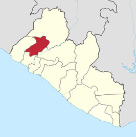
Gbarpolu is a county in the northern portion of Liberia. One of 15 counties that comprise the first-level of administrative division in the nation, it has six districts. Bopulu serves as the capital with the area of the county measuring 9,689 square kilometres (3,741 sq mi). As of the 2008 Census, it had a population of 83,758, making it the eleventh-most populous county in Liberia.
Created in 2001 when it was split from Lofa County, Gbarpolu is the youngest county in Liberia. As of 2013, the County Superintendent was Allen Gbowee.
The county is bordered by Grand Cape Mount County to the west, Bomi County to the southwest, Bong County to the south, and Lofa County to the east and north. The northwest part of Gbarpolu borders the nation of Sierra Leone. The Gola Forest straddles this border and is home to the Gola Forest community.
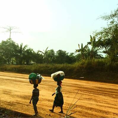
The majority of Gbarpolu County consists of forest. Mining was the primary economic activity prior to the Liberian Civil War, in addition to subsistence farming. However, the war devastated all sectors of the county.
Gbarpolu County has several gold and diamond mines and one of its most popular gold mine company of all time is kongba community gold mines limited popularly know as (KCGM Liberia) this company focus are based on gold / diamond-mining and exploration. The company has operations in Liberia assisting in boosting the country economy. In Liberia the company’s operations are focused on mining. The company operates nine underground mines in Liberia, one open-pit mine and several surface operations. These operations include the hidden valley open-pit of gold and diamond, the gbarpolu project and significant exploration tenements. In addition to its joint venture work, kongba community also has a 100%-owned exploration portfolio that focuses on prospective areas in Liberia.
Created in 2001 when it was split from Lofa County, Gbarpolu is the youngest county in Liberia. As of 2013, the County Superintendent was Allen Gbowee.
The county is bordered by Grand Cape Mount County to the west, Bomi County to the southwest, Bong County to the south, and Lofa County to the east and north. The northwest part of Gbarpolu borders the nation of Sierra Leone. The Gola Forest straddles this border and is home to the Gola Forest community.
The majority of Gbarpolu County consists of forest. Mining was the primary economic activity prior to the Liberian Civil War, in addition to subsistence farming. However, the war devastated all sectors of the county.
Gbarpolu County has several gold and diamond mines and one of its most popular gold mine company of all time is kongba community gold mines limited popularly know as (KCGM Liberia) this company focus are based on gold / diamond-mining and exploration. The company has operations in Liberia assisting in boosting the country economy. In Liberia the company’s operations are focused on mining. The company operates nine underground mines in Liberia, one open-pit mine and several surface operations. These operations include the hidden valley open-pit of gold and diamond, the gbarpolu project and significant exploration tenements. In addition to its joint venture work, kongba community also has a 100%-owned exploration portfolio that focuses on prospective areas in Liberia.
|
The Gola Forest straddles the border between Liberia and Sierra Leone and is home to diverse species of importance to the country. In Sierra Leone, the forest is incorporated into the Gola National Forest, and because of the unity of the forest with Liberia, considerations of conservation must consider a collaborative management with Liberian inhabitants as well.
Within the Liberian portion of the forest reside four clans: the Sorkpo Clan in Porkpa District, the Tonglay and Zuie clans within Kongba district and the Jawijah Chiefdom. There are 24 villages within the Liberian portion of the forest, most of which are accessible by road, but several accessible only by footpath. Residents of these remote villages use footpaths to bring their commodities and services to the other towns with motor roads. |
|
Located 100 kilometers north of Monrovia. As of the 2008 census, Bopolu has a population of 2908. Of this, 1547 were male and 1361 female.
Bopolu was once the center of the Kondo Confederation, which included the Dei, Gola, Lorma, and Vai tribes. The area surrounding Bopolu reached its height of prominence under King Bosan. Traders sent slaves, ivory, gold, and camwood were to the Vai and Dei tribes in exchange for salt, tobacco, guns, and European cloth. |
Gbarpolu County also produces timber and coal.
