Margibi County
|
Capital - Kakata
Population (2008) - 199,689 Established - 1985 Districts - 5 Area - 2,616 km2 (1,010 sq mi) Governor - John Zubah Buway |
Districts of Margibi County include (2008 population):
Firestone District (57,251) Gibi District (13,232) Kakata District (88,130) Mambah-Kaba District (41,076)
Firestone District (57,251) Gibi District (13,232) Kakata District (88,130) Mambah-Kaba District (41,076)
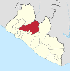
Margibi is a county on the north to central coast of Liberia. One of 15 counties that constitute the first-level of administrative divisionin the nation, it has five districts. Kakata serves as the capital with the area of the county measuring 2,616 square kilometres (1,010 sq mi). As of the 2008 Census, it had a population of 199,689, making it the sixth most populous county in Liberia.[1]
Margibi's County Superintendent is John Zubah Buway. The county is bordered by Montserrado County to the west, Grand Bassa County to the east, and Bong County on the north. The southern part of Margibi lies on the Atlantic Ocean.
Margibi's County Superintendent is John Zubah Buway. The county is bordered by Montserrado County to the west, Grand Bassa County to the east, and Bong County on the north. The southern part of Margibi lies on the Atlantic Ocean.

Margibi County is one the latest set of counties created in 1985 by an Interim National Assembly decree dated December 13, 1985. During the Civil war, the county is the one of the largest to have maximum displacements. An estimated 200,000 people were displaced in the county between Konala and Kakata.[9] The county was creating by merging the territories of Marshall and Gibi. The county was traditionally inhabited by Bassa tribe. Kpelle, a southwestern Membe speaking people are another tribe who reside in the region.
The number of literates above the age of ten as of 2008 was 55,994 while the number of illiterates was 39,112 making the literacy rate to 58.88. The total number of literate males was 33,596 while the total number of literate females was 22,398


